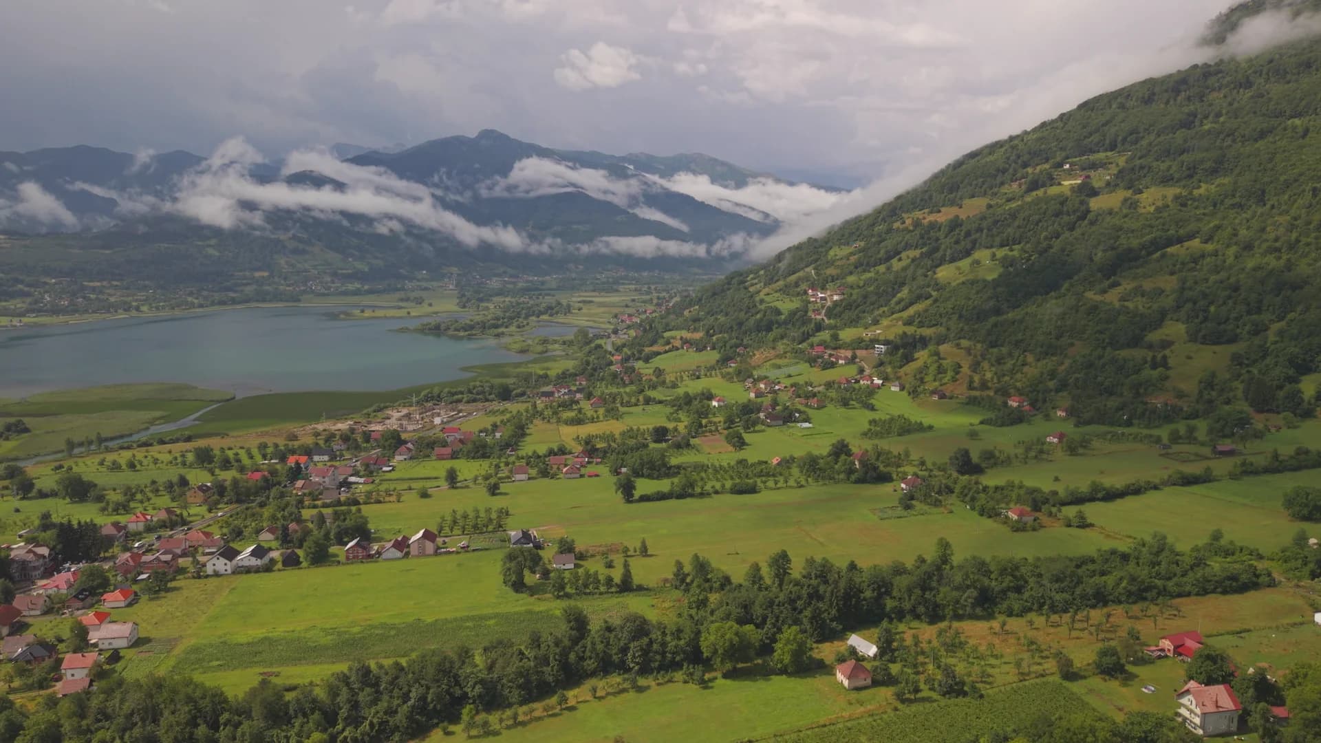
At Plav, water does not sit apart from the town; it organises the whole landscape. Mountain streams gather into the Ljuča, the river enters Lake Plav, and the lake’s outflow continues as the Lim. South-east toward Gusinje, water appears again at Ali Pasha Springs, where numerous clear upwellings spread across a broad meadow beneath the Prokletije massif.
These are not interchangeable photo stops. Lake Plav is a living lake-edge environment beside a regional town. Ali Pasha Springs are a karst source landscape with cultural meaning, especially for families connected to the Plav–Gusinje area and its diaspora. Visiting both in one day shows how water links ecology, movement, memory and settlement in Montenegro’s north-east.

What the original report got right—and what needed correction
The original Montenegro.com story recognised the essential relationship among Plav, its lake, Prokletije and Ali Pasha Springs. It also preserved an important social observation: late-summer gatherings at the springs draw people whose families left the region, including members of a large overseas diaspora. That is more revealing than a list of scenic adjectives.
Some inherited claims were too absolute. Lake Plav should not be promoted through an unsupported ranking as the “second largest and most beautiful” glacial lake in the former Yugoslavia. Ali Pasha Springs are frequently advertised as being inside Prokletije National Park, while the park authority’s current visitor material places them in the park’s contact zone. And the old text’s accidental “Damn it” was evidently a failed translation of Prokletije, often rendered in English as the Accursed Mountains.
The corrected account is stronger: a glacially shaped mountain lake within the Ljuča–Lim catchment; a group of powerful karst springs near Gusinje; and a national-park landscape beginning close by. Our complete Plav guide provides the wider town context, while the Gusinje guide continues toward the valleys below Prokletije.

The water system in one table
| Feature | Role in the landscape | Good visitor use | Key caution |
|---|---|---|---|
| Ljuča | Main visible inflow to Lake Plav | River views and low-impact paddling where locally permitted | Current and water level vary |
| Lake Plav | Lake basin beside Plav; source reach of the Lim system | Shore walk, bird observation, paddling with local advice | Do not infer safe swimming from calm water |
| Lim | Outflow continuing north from the lake | Landscape and river interpretation | Fishing and water activities can require rules or permits |
| Ali Pasha Springs | Multiple karst upwellings near Gusinje | Short walk, photography and cultural gathering | Contact-zone meadow, not an amusement site |
| Oko Skakavice and Grlja | Spring, waterfall and canyon system farther toward Prokletije | Separate excursion with local route advice | Do not combine casually in poor weather |
| Stage | Element |
|---|---|
| Inflow source | mountain catchments |
| Feeder river | Ljuča |
| Body of water | Lake Plav |
| Outflow river | Lim |
| Note | Schematic only; not to scale |
Source: gov.me
Lake Plav: how to spend the shore time
Begin with orientation, not activity. Look for where the broad mountain amphitheatre opens toward the lake and where settlement meets wet ground. The most rewarding visit combines a shore walk with time in Plav itself. Redžepagić Tower, mosques, Orthodox heritage and the town’s everyday commercial life keep the lake from becoming a detached “nature product.”
For paddling, fishing or swimming, ask a local operator or the tourist organisation about current conditions. Water temperature, wind, vegetation, access and regulations are seasonal. Never treat the absence of a warning sign as confirmation that an informal access point is safe. Launch only from an appropriate place, use a buoyancy aid and avoid disturbing reed margins.
A circuit can continue toward Plav, Brezojevica and the Lim. Travellers building a wider northern itinerary can compare this open inhabited lake with the forest setting in our Biogradsko Jezero guide.
Ali Pasha Springs: landscape and gathering place
Near Gusinje, water rises through many points in the ground and gathers into clear channels across the meadow. The effect is broad and horizontal rather than a single dramatic jet. Walk slowly enough to notice how vegetation marks wet and dry ground, and keep off fragile saturated patches where repeated footsteps widen erosion.
The National Tourism Organisation highlights the late-August gathering associated with the springs, while the older Montenegro.com report remembered a traditional gathering on 2 August. Those references likely describe related but not necessarily identical programmes. Event calendars change, so this guide does not promise one fixed date. Check with the Tourist Organisation of Plav or local authorities before making a journey around an event.

Promotional pages sometimes invite visitors to drink directly from clear springs. Clarity is not a laboratory test, and conditions can change after rain, grazing or maintenance. Carry your own water unless a competent local authority confirms potability at a designated point. The same caution applies to entering channels: admire the hydrology without trampling banks or treating a culturally important gathering place as a wild swimming pool.

Prokletije beyond the springs
The springs are a gateway view, not a substitute for the mountains. Prokletije National Park was established in 2009 and covers territory in the municipalities of Plav and Gusinje. Park material describes smaller watercourses, drinking-water sources and mountain pools, while its guided-route programme includes an Ali Pasha Springs–Gerani–Vusanje itinerary.
Those routes should not be reduced to a quick extension after lunch. Mountain weather, navigation, border proximity and terrain require preparation. Use our Montenegro hiking guide for risk planning, then confirm the actual trail with the park or a licensed guide. The international Peaks of the Balkans circuit is a multi-day undertaking, not a signposted stroll from the springs.

For another high-mountain lake with a very different scale and access pattern, see our account of Hridsko Jezero. It belongs in a dedicated excursion rather than a rushed three-lake checklist.
A cultural landscape, not empty wilderness
The Plav–Gusinje basin can look overwhelmingly natural in a wide photograph, but every useful route passes through a cultural landscape. Fields are worked, animals graze, water is channelled, families return from abroad and religious buildings record communities that have lived beside one another for generations. The tourism organisation presents Orthodox, Muslim and Catholic heritage as part of the area’s identity; visitors should resist treating the valley as a vacant foreground to the mountains.
That is especially important at Ali Pasha Springs. On an ordinary day, the meadow may feel quiet. During a gathering it becomes social space, connected to family memory and return. Do not fly a drone over people, stage photographs in the middle of a ceremony or assume that traditional food, music or dress has been performed for tourists. Ask before photographing individuals and leave room for local use of paths and water edges.
The old story’s thanks to photographer Sead Jasavić also belongs in this record. His images allowed readers far from Plav to see the lake and springs long before today’s highly visual destination marketing. Retaining that credit is part of accurate authorship: the current guide verifies geography and practical claims, while the surviving photographs preserve an earlier local view.
That continuity matters for visitors too: the most respectful itinerary leaves space for contemporary community life instead of presenting the basin as scenery frozen in the past.
Choosing the season
Late spring brings strong water and green valley colour, but high routes can still hold snow. Summer offers the widest range of activities and events, with stronger sun, larger gatherings and more demand for parking. Early autumn can bring clear walking conditions and quieter shores, while shorter days reduce the margin for adding mountain detours. Winter changes the journey entirely: snow, ice and reduced services mean that a lake-and-springs drive should not be treated as a summer itinerary with warmer clothes.
No season removes the need to check the forecast. Prokletije can generate rapid local changes, and conditions at the lake do not prove conditions at altitude. If rain is persistent, favour the town, cultural sites and established viewpoints over canyon edges or improvised tracks.
Carry cash for small local purchases, take litter back to town and keep a light layer available even when the valley forecast looks warm.
Practical day plan
Morning: begin in Plav and walk an established section of lakeshore while wind is often lighter. Add one cultural stop in town rather than circling by car in search of a perfect angle. Midday: eat in Plav or Gusinje and confirm road and weather conditions. Afternoon: visit Ali Pasha Springs, allowing unhurried time at the meadow. Add Oko Skakavice or Grlja only if access, daylight and local advice support it.
A private vehicle gives the most flexibility. Distances on a map can understate travel time on local roads. Download an offline map, keep fuel above reserve and do not park on grass or beside a spring channel. Public transport may connect the towns but rarely functions as a timed sightseeing loop; confirm the return before departing.
Frequently asked questions
Are Ali Pasha Springs inside Prokletije National Park?
The park authority describes them as being in the park’s contact zone. They are closely associated with a Prokletije visit, but the distinction matters for accurate geography and management.
Can I swim in Lake Plav?
Conditions vary. Ask locally about designated access, water conditions and any current notices. Cold water, wind, vegetation and an informal bank can create risk even when the surface appears calm.
Can Lake Plav and the springs fit into one day?
Yes. A focused day can include Plav, a lakeshore walk, Gusinje and Ali Pasha Springs. Do not add a serious Prokletije hike unless it has been planned separately with sufficient daylight and equipment.
When is the diaspora gathering?
Sources describe important summer gatherings, but dates and programmes can change. Confirm with the local tourist organisation before booking around a specific celebration.